Bestaand:Map of Oregon NA.png

Groutde van disse weadergåve: 800 × 541 bealdpunten. Andere resolutys: 320 × 217 bealdpunten | 640 × 433 bealdpunten | 1.024 × 693 bealdpunten | 1.280 × 866 bealdpunten | 1.967 × 1.331 bealdpunten.
Oorsprungelik bestand (1.967 × 1.331 bealdpunten, bestandsgroutde: 2,15 MB, MIME-type: image/png)
Beskryving
| Beskryving |
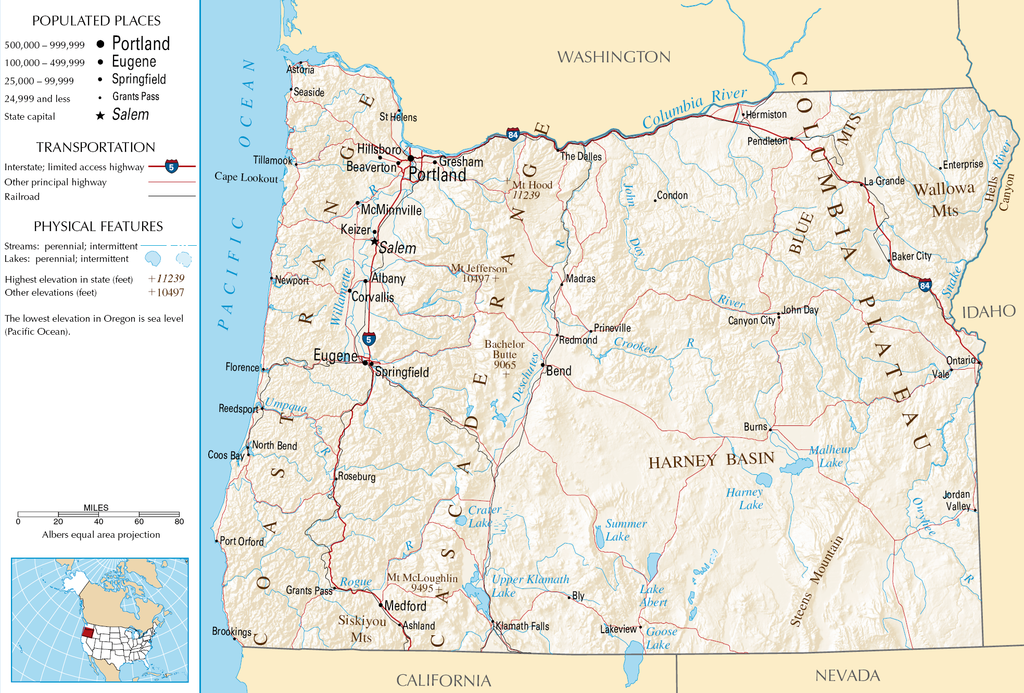
English: Topographic map of the geography of Oregon — with major rivers shown.
|
| Bron | National Atlas |
| Autöör | Onbekend |
Licensy
This map was obtained from an edition of the National Atlas of the United States. Like almost all works of the U.S. federal government, works from the National Atlas are in the public domain in the United States.
Online access: NationalAtlas.gov | 1970 print edition: Library of Congress, Perry-Castañeda Library
|
Bestandsgeskydenisse
Klik up een datum/tyd üm et bestand te seen so as et destyds was.
| Datum/tyd | Miniatuurafbealding | Groutde | Gebruker | Kommentaar | |
|---|---|---|---|---|---|
| aktueel | 07:46, 16 okt 2007 | | 1.967 × 1.331 (2,15 MB) | Peteforsyth | removed extraneous text and logo from public domain image |
| 10:13, 15 aug 2006 |  | 2.122 × 1.640 (2,75 MB) | Huebi~commonswiki | {{Information| |Description=Map of Oregon |Source=[http://www.nationalatlas.gov National Atlas] }} Category:Maps of the United States Category:Maps of Oregon {{PD-USGov-Atlas}} |
Bestandsgebruuk
Dit bestand wördt up de volgende syde gebruked:
Globaal bestandsgebruuk
De volgende andere wikis gebruken dit bestand:
- Gebruuk up als.wikipedia.org
- Gebruuk up ar.wikipedia.org
- Gebruuk up de.wikipedia.org
- Gebruuk up en.wikipedia.org
- Gebruuk up eo.wikipedia.org
- Gebruuk up fi.wikipedia.org
- Gebruuk up fr.wikipedia.org
- Gebruuk up hr.wiktionary.org
- Gebruuk up hsb.wikipedia.org
- Gebruuk up hu.wikipedia.org
- Gebruuk up incubator.wikimedia.org
- Gebruuk up is.wikipedia.org
- Gebruuk up it.wikipedia.org
- Gebruuk up ja.wikipedia.org
- Gebruuk up kk.wikipedia.org
- Gebruuk up lt.wikipedia.org
- Gebruuk up mr.wikipedia.org
- Gebruuk up pa.wikipedia.org
- Gebruuk up ru.wikipedia.org
- Gebruuk up sw.wikipedia.org
- Gebruuk up vi.wikipedia.org
- Gebruuk up zea.wikipedia.org