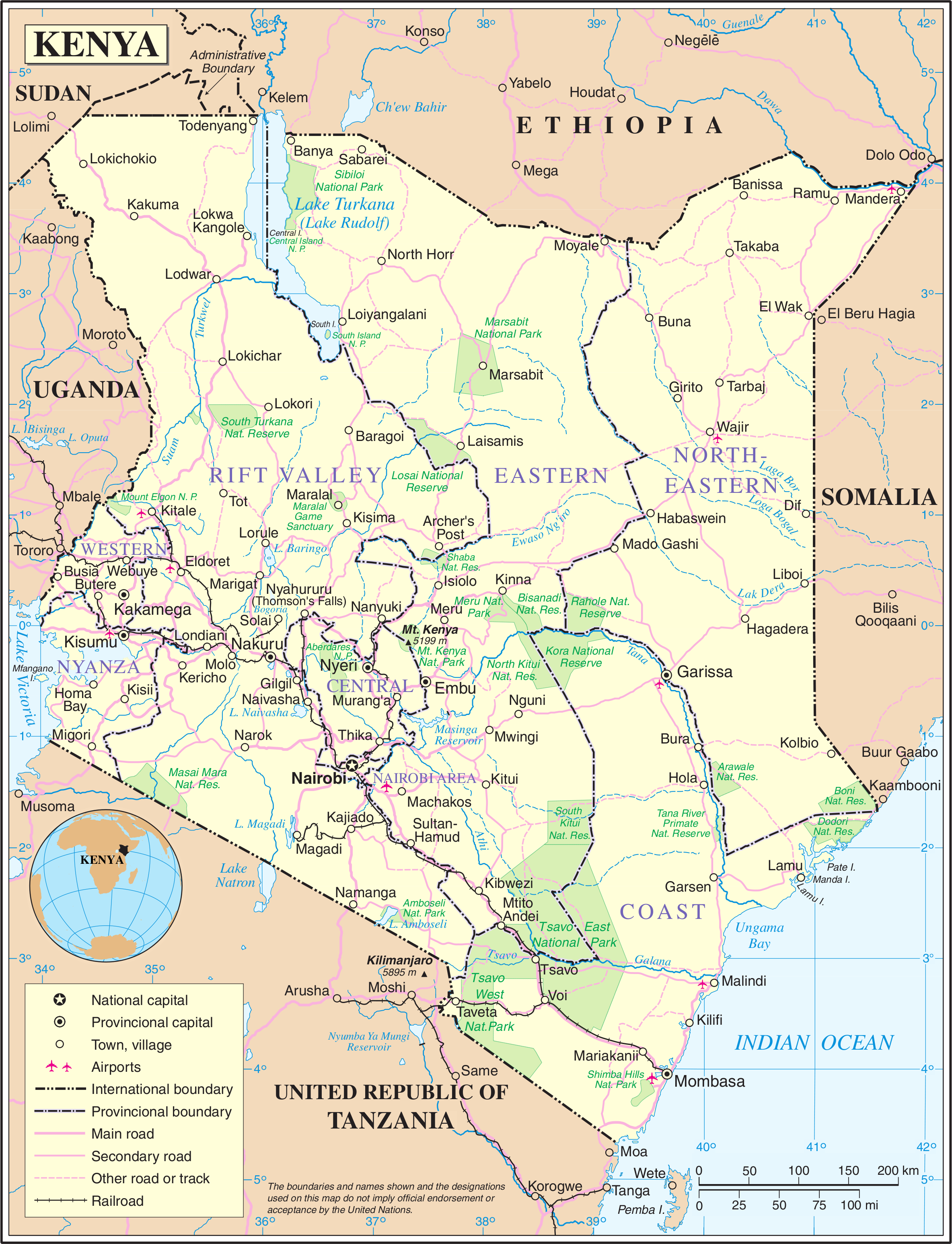
Bestaand:Un-kenya.png
Oorsprungelik bestand (2.367 × 3.092 bealdpunten, bestandsgroutde: 2,04 MB, MIME-type: image/png)
| This image is a map derived from a United Nations map.
Unless stated otherwise, UN maps are to be considered in the public domain. This applies worldwide. UN maps are, in principle, open source material and you can use them in your work or for making your own map. UN requests however that you delete the UN name, logo and reference number upon any modification to the map. Content of your map will be your responsibility. You can state in your publication, if you wish, something like: based on UN map … (map name, map number, revision number and date). See: Geospatial Information Section. And: Geospatial, location data for a better world. |
 |
http://www.akwaaba.nl/foto's%20en%20plaatjes/kaart_kenia.jpg
Bestandsgeskydenisse
Klik up een datum/tyd üm et bestand te seen so as et destyds was.
| Datum/tyd | Miniatuurafbealding | Groutde | Gebruker | Kommentaar | |
|---|---|---|---|---|---|
| aktueel | 02:15, 22 okt 2007 | | 2.367 × 3.092 (2,04 MB) | Jeroen | {{UN map}} Category:Maps of Kenya |
Bestandsgebruuk
Dit bestand wördt up de volgende syde gebruked:
Globaal bestandsgebruuk
De volgende andere wikis gebruken dit bestand:
- Gebruuk up ar.wikipedia.org
- Gebruuk up azb.wikipedia.org
- Gebruuk up az.wikipedia.org
- Gebruuk up bn.wikipedia.org
- Gebruuk up en.wikipedia.org
- Gebruuk up es.wikipedia.org
- Gebruuk up fa.wikipedia.org
- Gebruuk up fi.wikipedia.org
- Gebruuk up hu.wikipedia.org
- Gebruuk up hy.wikipedia.org
- Gebruuk up incubator.wikimedia.org
- Gebruuk up io.wikipedia.org
- Gebruuk up my.wikipedia.org
- Gebruuk up nds.wikipedia.org
- Gebruuk up nl.wikipedia.org
- Gebruuk up pl.wikipedia.org
- Gebruuk up pl.wiktionary.org
- Gebruuk up si.wikipedia.org
- Gebruuk up sl.wikipedia.org
- Gebruuk up sr.wikipedia.org
- Gebruuk up te.wikipedia.org
- Gebruuk up tr.wikipedia.org
- Gebruuk up uk.wikipedia.org
- Gebruuk up www.wikidata.org