Bestaand:India relief location map ganges highlighted.jpg

Groutde van disse weadergåve: 557 × 600 bealdpunten. Andere resolutys: 223 × 240 bealdpunten | 446 × 480 bealdpunten | 713 × 768 bealdpunten | 951 × 1.024 bealdpunten | 1.500 × 1.615 bealdpunten.
Oorsprungelik bestand (1.500 × 1.615 bealdpunten, bestandsgroutde: 617 kB, MIME-type: image/jpeg)
Beskryving
| Beskryving |
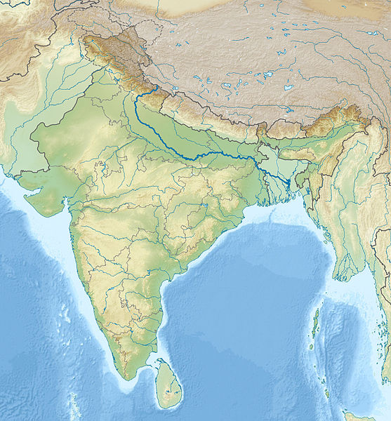
English: Location map of India with the Ganges highlighted. This can be an alternative map to be used with Template:Location map India. Equirectangular projection. Geographic limits of the map: top=37.5, bottom=5.0, left=67.0, right=99.0 |
| Dåtum | (UTC) |
| Bron | |
| Autöör |
|
| Dit is een geretoucheerde foto, wat betekent dat de originele versie digitaal aangepast is. Het origineel kan hier bekeken worden: India relief location map.jpg.
|
Licensy
Ik, de autöörsrechtholder van dit wark, geave disse media uut under de volgende licensy:
Dit bestand valt under de Creative Commons-licensy Naamsvermelding-Lyke deylen 3.0 neet porteerd
- Jy möäget:
- üm te deylen – et wark kopieren, verspreiden en döärgeaven
- üm te hermengen – et wark anpassen
- Under de volgende vöärwaerden:
- naamsvermelding – Jy müttet up en nette manere an naamsvermelding doon, en verwysing nå de licensy geaven en angeaven of der anpassingen dån bint. Jy möäget dit up elke readelike manere doon, mär neet up sou'n manere dat et de indrük wekt dat de lincensyholder juw wark understöänt of juw gebruuk van syn wark.
- lyke deylen – As jy materiaal menget, veranderet, of derup voordbouwet, dan müt jy juw bydragen verspreiden under deselvde of een vergelykbåre licensy as de oorsprungelike.

|
Der wördt tostemming geaven vöär et kopieren, verspreiden en/of wysigen van dit dokument under de vöärwaerden van de GNU-licensy vöär vrye dokumentaty, versy 1.2 of een latere versy so as uutgeaven döär de Free Software Foundation; sunder unveranderlike sektys, sunder ümslagteksten vöär of achter. Een kopy van de licensy is upnöämen in de sekty GNU-licensy vöär vrye dokumentaty. |
Jy möäget selv eyn van de licensys kesen.
Oorspronkelik logboek mit nieje bestaanden
This image is a derivative work of the following images:
- File:India_relief_location_map.jpg licensed with Cc-by-sa-3.0, GFDL
- 2010-04-23T15:31:11Z Uwe Dedering 1500x1615 (2100573 Bytes) {{Information |Description={{en|1=Location map of India. Equirectangular projection. Strechted by 106.0%. Geographic limits of the map: * N: 37.5° N * S: 5.0° N * W: 67.0° E * E: 99.0° E Made with Natural Earth. Free vect
Uploaded with derivativeFX
Bestandsgeskydenisse
Klik up een datum/tyd üm et bestand te seen so as et destyds was.
| Datum/tyd | Miniatuurafbealding | Groutde | Gebruker | Kommentaar | |
|---|---|---|---|---|---|
| aktueel | 21:02, 17 nov 2010 | | 1.500 × 1.615 (617 kB) | 배우는사람 | {{Information |Description={{en|1=Location map of India with the Ganges highlighted. This can be an alternative map to be used with Template:Location map India.}} |Source=*File:India_relief_location_map.jpg |Dat |
Bestandsgebruuk
Dit bestand wördt up de volgende syde gebruked:
Globaal bestandsgebruuk
De volgende andere wikis gebruken dit bestand:
- Gebruuk up ace.wikipedia.org
- Gebruuk up ar.wikipedia.org
- Gebruuk up azb.wikipedia.org
- Gebruuk up bn.wikipedia.org
- Gebruuk up bs.wikipedia.org
- Gebruuk up bug.wikipedia.org
- Gebruuk up ceb.wikipedia.org
- Gebruuk up ckb.wikipedia.org
- Gebruuk up diq.wikipedia.org
- Gebruuk up dty.wikipedia.org
- Gebruuk up dv.wikipedia.org
- Gebruuk up el.wikipedia.org
- Gebruuk up en.wikipedia.org
- Gebruuk up eo.wikipedia.org
- Kolkato
- Nov-Delhio
- Mumbajo
- Taĝ-Mahalo
- Delhio
- Sentinelanoj
- Dezerto Tar
- Agra
- Prajagraĝo
- Kanpur
- Gaziabad
- Ĉandigaro
- Ŝablono:Geokesto lokumilo Barato
- Novmumbajo
- Gvalior
- Maduraj
- Hubli
- Ĝalandar
- Salem (Barato)
- Aligor
- Kota (Raĝastano)
- Barejli
- Tiruĉirapali
- Moradabad
- Gorakhpur
- Ĝamŝedpur
- Bikaner
- Koĉi (Barato)
- Raĝpur Sonarpur
- Siliguri
- Kolhapur
- Sangli
- Aĝmer
Globaal gebruuk van dit bestand bekyken.